
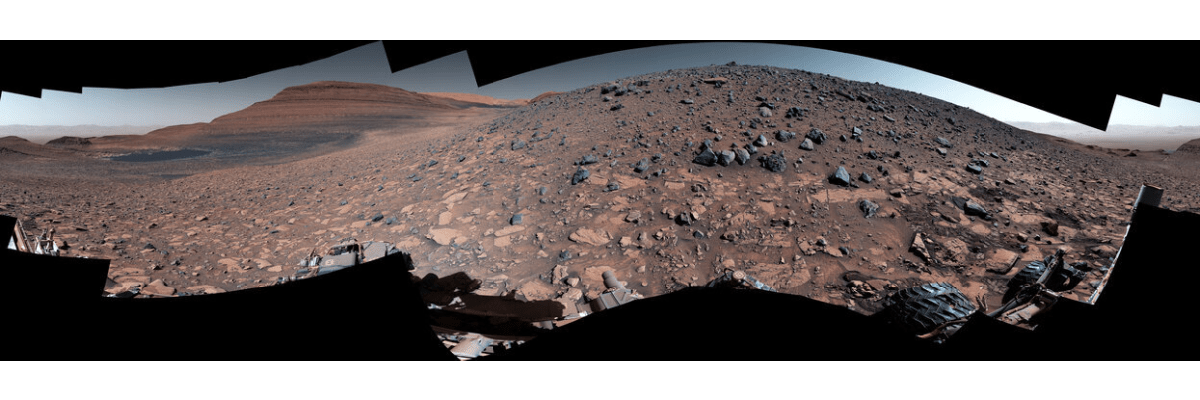
About three billion years ago, rushing water on Mars carried mud and boulders down a steep slope and deposited them into a vast fan-shaped debris pile. NASA’s Curiosity Rover has been trying to reach a ridge overlooking the region, and now finally, the rover has reached this vantage point after three years of climbing. NASA released a 360-degree view image of the region, showing the jumble of rocks strewn about by the rushing water. Now, Curiosity is reaching out to touch and study them.
Getting to this location, called Gediz Vallis Ridge, was not easy. For Curiosity to be able to take this photo, it took three different attempts to reach the top of the ridge.
“After three years, we finally found a spot where Mars allowed Curiosity to safely access the steep ridge,” said Ashwin Vasavada, Curiosity’s project scientist at NASA’s Jet Propulsion Laboratory, in a NASA update. “It’s a thrill to be able to reach out and touch rocks that were transported from places high up on Mount Sharp that we’ll never be able to visit with Curiosity.”
Previous attempts were thwarted by knife-edged “gator-back” rocks and extremely steep slopes. Scientists and engineers said this was one of the most difficult climbs of the mission to date. Curiosity arrived at the ridge on August 14, 2023 and now is finally studying this area.
The overarching goal of the mission has been to climb the lower part of 3-mile-tall (5-kilometer-tall) Mount Sharp. Ever since the rover landed in Gale Crater on Mars, it has discovered evidence of ancient lakes and streams along the way. As the rover ascends the mountain, each layer provides a history of different Martian eras. As Curiosity ascends, scientists are learning how the landscape changed over time. Gediz Vallis Ridge was among the last features on the mountain to form, making it one of the youngest” geological time capsules” Curiosity will see.

The rover has been studying rocks by taking photos and sending them to Earth, and using the instruments on its robotic arm to studying them even deeper.
The photos have provided scientists the first up-close views of the eroded remnants of a geologic feature known as a debris flow fan, where debris flowing down the slope spreads out into a fan shape. Debris flow fans are common on both Mars and Earth, but scientists are still learning how they form.

“I can’t imagine what it would have been like to witness these events,” said geologist William Dietrich, a mission team member at the University of California, Berkeley, who has helped lead Curiosity’s study of the ridge. “Huge rocks were ripped out of the mountain high above, rushed downhill, and spread out into a fan below. The results of this campaign will push us to better explain such events not just on Mars, but even on Earth, where they are a natural hazard.”
NASA says that while scientists are still poring over the imagery and data from Gediz Vallis Ridge, the journey continues for Curiosity. Mission planners have already begun working towards the rover’s next challenge: finding a path to the channel above the ridge so that scientists can learn more about how and where water once flowed down Mount Sharp.